Revealing the widespread potential of forests to increase low level cloud cover
- Select a language for the TTS:
- UK English Female
- UK English Male
- US English Female
- US English Male
- Australian Female
- Australian Male
- Language selected: (auto detect) - EN
Play all audios:
ABSTRACT Forests play a key role in humanity’s current challenge to mitigate climate change thanks to their capacity to sequester carbon. Preserving and expanding forest cover is considered
essential to enhance this carbon sink. However, changing the forest cover can further affect the climate system through biophysical effects. One such effect that is seldom studied is how
afforestation can alter the cloud regime, which can potentially have repercussions on the hydrological cycle, the surface radiation budget and on planetary albedo itself. Here we provide a
global scale assessment of this effect derived from satellite remote sensing observations. We show that for 67% of sampled areas across the world, afforestation would increase low level
cloud cover, which should have a cooling effect on the planet. We further reveal a dependency of this effect on forest type, notably in Europe where needleleaf forests generate more clouds
than broadleaf forests. SIMILAR CONTENT BEING VIEWED BY OTHERS CONTRASTING IMPACTS OF FORESTS ON CLOUD COVER BASED ON SATELLITE OBSERVATIONS Article Open access 03 February 2022
DEFORESTATION AMPLIFIES CLIMATE CHANGE EFFECTS ON WARMING AND CLOUD LEVEL RISE IN AFRICAN MONTANE FORESTS Article Open access 14 August 2024 DECREASED CLOUD COVER PARTIALLY OFFSETS THE
COOLING EFFECTS OF SURFACE ALBEDO CHANGE DUE TO DEFORESTATION Article Open access 26 August 2024 INTRODUCTION Forests provide a multitude of essential services to human society. These
include the capture, storage and regulation of water flows, the improvement of air and water quality, the supply of timber, energy and erosion control, the provision of habitat for
biodiversity and livelihoods for humans. There is a particular service that forests have that has come to prominent attention in recent years, and it relates to their interactions with the
climate system and their climate change mitigation potential1. To avoid the more dire consequences of climate change, humankind not only needs to stop emitting greenhouse gases into the
atmosphere, but the excess carbon that has already been emitted must also be removed2. Currently, the most realistic technique to effectively capture carbon (among what are known as negative
emission technologies or NETs) is to have it sequestered by trees3,4. However, to reach the necessary mitigation targets this effectively requires expanding the land covered by forests3,4
by means of ambitious forest restoration or afforestation programmes5,6. Along this line, various large-scale efforts in planting trees have recently emerged7, including the Sub-Saharan
Great Green Wall8, the Ant Forest in China9, and the extensive afforestation programme foreseen under the European Green Deal10. Yet planting trees is not a simple solution and can have
various climate impacts and mitigation efficacy depending on how and where they are planted7,11. Simplistic approaches to tree restoration that do not properly account for the complexities
of the plant–atmosphere interactions may underestimate the amount of land needed and overall provide a dangerous and misleading message12,13,14,15. Ultimately, it is becoming increasingly
evident that land-based climate mitigation through afforestation, forest restoration or avoided deforestation should be based on the comprehensive assessment of both the biogeochemical and
the biophysical processes triggered by forest cover change 16. Planting trees also affects climate by other means than carbon sequestration. Complex and non-linear forest–atmosphere
interactions can dampen or amplify anthropogenic climate change1,17. For instance, by having access to more ground water with their deeper rooting system, trees can sustain higher
transpiration rates during droughts compared to nearby grasslands or croplands, contributing to the mitigation of heatwaves18. On the other hand, their comparatively lower albedo can
generate warming to an extent that may even offset their carbon sequestration mitigation potential at higher latitudes, where the difference between dark conifer trees and neighbouring
snow-covered open land is large19. Depending on which of these different forces prevails, the local net effect of vegetation cover change on land surface temperature can change
geographically and seasonally1, as demonstrated by recent global studies based on satellite remote sensing observations20,21,22. Such observation-driven analyses are currently helping to
evaluate23,24 and improve25 land surface models, and they are further inspiring the design of tools for assessing land-based climate policies26. Forest cover change can further have indirect
biophysical effects on the climate. These are indirect because they do not stem from changes in the properties of the surface directly, but rather from the effect the surface has on the
atmospheric boundary layer (ABL) above it. The best example is the increased formation of low-level convective clouds above forests27,28,29,30,31. Increased cloud cover can further affect
the water cycle by triggering an increase of precipitation32,33. The fact that Earth’s vegetation cover can affect rainfall has been known for a long time27. The Amazon forest generates
about half of its own rainfall by recycling moisture lost through evaporation34. This effect can also go beyond trees: high-yielding corn planted in the US Corn Belt was shown to alter the
regional climate patterns by inducing cloud formation and thus generating more rain in summer35. By modifying the light environment and tempering the build up of heat, the formation of
boundary layer cumulus clouds above forests further appears to provide favourable conditions for carbon uptake29. But the radiative consequences may be more profound at planetary level.
Theoretical work has shown that increases in evaporation (as would occur after considerable afforestation of large parts of the world) can increase low-elevation cloudiness, which increases
the planetary albedo to the point of cooling the whole Earth system36. Clouds remain a very sensitive and uncertain component of the climate system37,38,39. They indeed play an important
role in regulating Earth’s radiative budget by modulating the amount of energy reflected, emitted and absorbed both at the surface and in the atmosphere37. Different types of clouds have
different effects on both surface and planetary energy balance: low clouds typically have a cooling effect by reflecting radiation back into space, while high clouds tend to have a warming
effect as they trap radiation and emit it back to the surface40. On average, clouds exert a net cooling effect on climate, with a large contribution of the low-level cloud41. The radiative
effects of low-level clouds could further affect deep-convection, influencing the tropics-wide circulation and precipitation42. The generation of low clouds follows the day–night cycle of
solar flux. During daytime the destabilization of the boundary layer by solar heating of the surface drives convection and forms cumuliform clouds. At night the boundary layer cools,
eventually causing condensation to form stratiform clouds, which cool down by emitting longwave radiation back into space43. Over land, the clouds with more pronounced diurnal cycles are
cumuliform clouds, they seem to be the dominant cloud type over most areas during spring and summer, and they peak invariably around 14:00 in the afternoon43. What are the underlying
mechanisms explaining the interplay between clouds and tree canopies? Forests have larger net radiation and surface roughness than open lands, favouring a better exchange of heat, moisture
and momentum with the atmosphere, which in turn can generate a stronger convection and a deeper ABL44,45. The co-occurrence of an effective lifting mechanism (provided by the sensible heat
flux) and sufficient water vapour (provided by the latent heat flux) support the generation of convective clouds in the lower troposphere31. Furthermore, research suggests that, thanks to a
feedback between cloud generation and its subsequent effect on the incoming radiation, forests tend to foster the establishment of an equilibrium between the temperature and moisture
tendencies ensuring that these cloud-forming conditions endure46. Cloud formation is further affected by several other vegetation properties such as the access to deep soil water47,
landscape fragmentation48,49 and even by the emissions of biogenic volatile organic compounds (BVOCs)50. BVOCs are complex molecules that plants (and trees in particular) produce to regulate
various processes such as plant growth, reproduction and defence, but they also rapidly oxidize in the atmosphere into secondary organic aerosols that can grow into cloud condensation
nuclei51. The complexity of these multiple processes affecting the interplay between forests and cloud formation partly explains why observational evidence on the impact of land use can
disagree in magnitude and sign depending on the season and the region of the world under investigation31,49,52. Given this substantial uncertainty in how and where forest can influence cloud
formation, there is a compelling case to address a comprehensive global assessment that can guide land-based mitigation strategies of afforestation or forest restoration. This is especially
critical as the indirect effect of cloud formation can potentially offset the direct biophysical effects of land cover change53. Process-oriented Earth system models are theoretically the
ideal tools to reach this goal, as they attempt to represent all land–atmosphere interactions in a self-consistent way. However, models still struggle to represent adequately some processes
linked to cloud formation, and they are also limited by the computational difficulty to finely represent these complex biophysical effects at kilometric scale, which would be the reasonable
spatial resolution to address realistic land-based mitigation strategies. Satellite remote sensing technology offers an alternative path, as it can effectively provide synchronous
estimations of both cloud and land cover in a spatially and temporally consistent way. Unlike with models, there is a limit to how much process-understanding can be made based solely on
remote sensing measurements, since not all land–atmospheric processes can be fully observed. However, this technique offers a unique opportunity to study the effects of land cover change on
cloud cover in a consistent manner across seasonal and latitudinal gradients. In this study we make a global-scale observational assessment of where afforestation could lead to an increased
cloud formation by exploiting satellite data products. Our study shows that afforestation generally leads to an increase in low cloud cover over most of the world, and predominantly in the
warmer months of the years. These results are comforted by a series of ancillary analyses using either an alternative methodology, a finer scale dataset or even ground-based observations. We
further found that different types of forests can have stronger effects on low-level cloud formation. We expect this work to serve as a valuable observational benchmark for climate models,
which should improve our general understanding of the Earth System, and also to guide the design of ambitious nature-based mitigation policies such as the European Green Deal. RESULTS AND
DISCUSSION GLOBAL PATTERNS OF CLOUD FORMATION To characterize the potential effect that afforestation could have on low convective cloud formation, the main approach we use relies on a
substitution of space-for-time over a local moving window. As explained in detail in the ‘Methods’ section, we are able to isolate this local effect of low-level cloud formation by
systematically comparing neighbouring observations of cloud occurrence over locally contrasting landscapes, whilst ensuring observations are made at the time of peak convective cloud
formation to limit effects of lateral advection, and carefully avoiding topographical effects. The approach relies on combining climate data records of land cover54 and cloud fractional
cover (CFrC) derived from a climatology of satellite observations covering the period 2004–201455. The work is done at monthly temporal scale and with a moving window approach consisting of
7 × 7 cells, each with a spatial resolution of 0.05° (see ‘Methods’ section for details). An overview of the first comprehensive and observation-based global assessment of the effect of
forests on low cloud cover is presented in Fig. 1. While some areas can locally present a certain degree of spatial variability, as could be expected given the necessary assumptions needed
to isolate a process such as cloud formation (see ‘Methods’ section for details), there are remarkable macro-patterns of spatial consistency across large geographic areas. It is important to
note that, by design, the methodology to extract these local changes in CFrC is essentially sensitive to low-level clouds, and more precisely to boundary layer cumulus clouds (see ‘Methods’
section for details). Therefore, all changes shown in CFrC should be considered as changes in low-level convective clouds only. The spatial coverage in Fig. 1 is restricted to areas where
there is sufficient local co-occurrence of both forests and low vegetation cover (e.g. crops and grasslands) for the method to be applicable. Results are shown for transitions from low
vegetation towards forests, in order to represent the effect of potential afforestation and thus stay in the context of land-based mitigation. The change is expressed in relative terms with
respect to the average cloud cover over each grid cell, as provided by the input cloud product. The absolute change in CFrC is provided in a similar figure in the Supplementary material
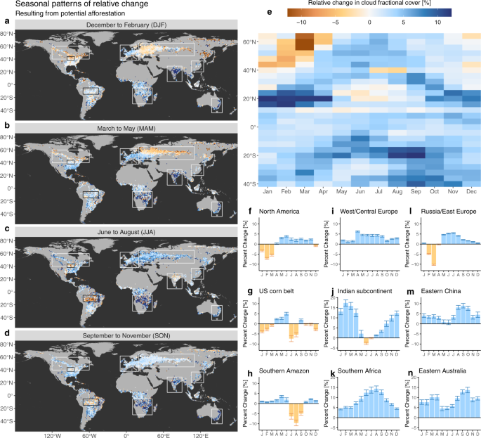
(Supplementary Fig. 1). Overall, we see that for 67% of the area we sampled across the world, extending forest cover is expected to result in an increase in cloud cover. Figure 2 shows how
this number rises above 74% during the period from May to September (after cycling the months in the Southern Hemisphere by 6 months to align the seasons according to incoming sunlight).
Most parts of the world display clear seasonal patterns of cloud formation following potential afforestation (Fig. 1a–e). The boreal summer is characterized by a relatively strong and
consistent increase of local CFrC over forests of the order of about 5% of the normal cloud fraction encountered at grid level, which in relative terms consists of an increase of 0.03 of
CFrC. However, during boreal winter and spring across large parts of North America, (Fig. 1f), Russia and Eastern Europe (Fig. 1l), corresponding to areas with prolonged snow cover, the
signal is inverted, meaning that there are less clouds over forest than over open land. Temperate regions, which do not have such long snow-covered periods, generally show positive increases
in CFrC throughout the year with milder changes in winter (e.g. West/Central Europe in Fig. 1i). We do see various regions that display a characteristic inversion in the sign of CFrC change
during periods and places where there is no snow (see Supplementary Fig. 3 for details), including the US Corn Belt in summer (Fig. 1g), the Indian subcontinent during the early monsoon
season (Fig. 1j) and the Southern part of the Amazon basin during the drier season (Fig. 1h). Finally, there are also other places with constantly positive differences in CFrC all along the
year with a marked seasonal cycle. For some regions, namely India and Southern Africa, the increase in relative terms can be strongly seasonal, with values reaching as high as 15% (Fig. 1j,
k). Eastern China (Fig. 1m) shows a strong contrast between a late spring with low-peak and a late summer with high-peak. Drier regions characterized with a combination of high air
temperature and high radiation load, such as Southern Africa (Fig. 1k) and Eastern Australia (Fig. 1g), seem to constantly have more clouds above forests. Several lines of experimental
evidence confirm that the cloud signal we extract is indeed related to potential forest cover change, and that it does not originate from possible artefacts linked to the space-for-time
methodology that we adopt nor to the uncertainty in satellite retrievals. A first possible artefact is linked to the spatial granularity of the analysis, both in terms of the spatial
resolution of the input CFrC data and the spatial window over which the space-for-time substitution is considered. By using an alternative implementation of the same data but with a higher
spatial resolution, which is only available over Europe, we demonstrate that the patterns of change remain comparable when considering a finer scale (see ‘Methods’ section for details). A
second possible artefact stems from the bias in the location of the forest within the landscape. In many areas around the world, forests occupy the more marginal lands that are less suitable
for agriculture, such as humid zones, areas with shallow soils and/or sloped terrain56. However, when repeating the analysis using an alternative methodology21, which is based on the
analysis of areas in which forest cover has effectively changed (instead of the potential change represented by neighbouring contrasting areas in the space-for-time method), results remain
largely consistent in terms of sign, albeit with different magnitudes that can be explained by the difference in nature of the transition (see Fig. 3 and ‘Methods’ section for details). A
final confirmation of our results comes from independent ground observations of CFrC recorded from SYNOP stations across Europe (see Fig. 4a and ‘Methods’ section for details). By
confronting CFrC values from paired sites with differences in forest cover, a clear rise in CFrC is evident from April to August and from late morning until mid-afternoon (Fig. 4b). Despite
a difference in magnitude, the seasonal excursion at the satellite overpass time (circa 14:00 local time) largely follows the seasonal pattern obtained from space over the corresponding
area, with the notable exception of the negative values in February and March (Fig. 4c). POSSIBLE UNDERLYING PHYSICAL MECHANISMS It is beyond the scope of this study to disentangle and
attribute all the physical processes acting towards generating or inhibiting cloud formations above forests across the world. These processes will vary considerably depending on various
factors such as weather, climate, vegetation physiology and soil moisture. While in some places cloud occurrence could be limited by the heating needed for uplift, in some it could be
limited by moisture supply. The relative importance of various different factors across different geographic locations would need dedicated studies based on modelling experiments where
different factors can be isolated (e.g.57). Such studies could build up from our present work by using it as a benchmark that models could strive to reproduce, and by doing so contribute to
the increased understanding of the underlying mechanisms. Having said that, we do provide here a brief discussion of possible drivers behind patterns we see in the resulting dataset. Snow is
a first driver that could affect the patterns in CFrC change that we observe. When land is covered by snow during winter and spring over northern latitudes, we see a clear reduction of CFrC
above forests with respect to open lands. A plausible reason for this pattern lies in differences in air stability above forests and snow-covered open lands. In snow-covered conditions, the
large sensible heat flux driven by the larger net radiation of forests combined with the low winter transpiration favours the development of a deep dry boundary layer that is more effective
in the vertical transport of momentum as compared to open areas1,58. This dry boundary layer prevents the development of low-level clouds, while over the neighbouring snow-covered open
lands the low value of net radiation leads to stable stratification and an increased probability of persistent fog. This radiation fog typically develops during the persistent anticyclonic
conditions during the winter, such as the Siberian High in northern Eurasia59. Incidentally, fog is also the most probable reason why the negative change in CFrC is not detected by ground
observations (Fig. 4), as these stations do not typically report CFrC when the sky is not visible in the presence of fog. Finally, confusion between clouds and snow can partially occur in
the satellite CFrC product, which would artificially lead to more (erroneously) detected clouds above open lands due to their higher snow coverage. Water availability is another factor that
can alter the general pattern of cloud formation over forests. Forests would typically have more access to ground water than neighbouring grasses due to their deeper roots, thus naturally
favouring more cloud formation. However, the case of the Indian subcontinent (Fig. 1j and Supplementary Fig. 3) illustrates how the magnitude of this effect can strongly change along the
season depending on water availability. During the dry season from December to April, trees still have access to water resulting in a higher CFrC than neighbouring crops/grasses. In May,
this difference drops dramatically as air temperature rise strongly and water becomes scarce for all plant types. Then, the changes in CFrC remain low during the monsoon period (June to
August), when the coupling between the land and the atmosphere is expected to be weak, only to progressively return to higher levels as the rainy season recedes and water becomes
increasingly less available especially for non-forested vegetation. In the beginning of the Monsoon, the CFrC even becomes slightly negative. One possible explanation might be that under a
situation of no water stress for neither grasses nor trees, the former are bound to transpire more as they have a lower Bowen ratio (given their lower hydraulic and stomatal resistance), but
further research would be needed to go beyond this speculation. In the US Corn Belt during summer we also observe a clear increase in cloud cover over croplands with respect to adjacent
forests (Fig. 1g and Supplementary Fig. 3). This is in line with a recent study that shows how agricultural intensification in this area is a major contributor to the observed increase in
summer rainfall35. A modelling study has similarly shown that C4 plants (such as corn) would have higher cloud cover than C3 plants under similar conditions due to their higher water
efficiency which translates into more vigorous buoyant thermals30. Finally, we should also recognize that irrigation has a strong biophysical effect60, which should also translate in changes
of cloud cover, but we could not explicitly isolate the effect of irrigation in our current experimental set-up (see ‘Methods’ for details). Landscape heterogeneity has also been reported
as a driver of cloud formation by both modelling28,61,62 and observational experiments49. This has notably been seen in the Amazon following deforestation, which typically starts along road
networks following a characteristic fishbone pattern, which then evolves into a heterogeneous complex dominated by croplands or grasslands mixed with forest remnants and settlements. Such a
fragmented landscape has a larger roughness length than the neighbouring intact and homogeneous forest, which enhances exchange of energy and momentum, generating a stronger lifting
mechanism and thus a relatively more active shallow convection regime over deforested areas49. This effect has been clearly observed during the dry season (around August) and has
repercussions with the amount of rainfall during that period63. The estimations we provide over the Amazon basin do follow this pattern of marked increase of CFrC over deforested areas (Fig.
1h and Supplementary Fig. 3). Finally, as mentioned before, another driver that could also affect the expected patterns of CFrC change are BVOCs. More specifically, we speculate that the
high values of CFrC enhancement observed over Eastern Australia may be related to the predominance of Eucalypts trees, which typically emit large quantities of BVOCs. Another place where
BVOCs would have a considerable role is in conifer forests53. This factor, combined with the higher Bowen ratio of needleleaf trees, may partly explain the fact that systematically higher
values of CFrC are detected over needleleaf forests compared to deciduous ones (see Fig. 5). IMPLICATIONS FOR LAND-BASED MITIGATION The widespread enhancement of cloud cover we observe over
most forests consolidates the notion that land-based mitigation through afforestation, forest restoration or avoided deforestation should not be reasoned purely in terms of carbon
sequestration1,16. Although our analysis does not directly relate cloud formation to rainfall, we can anticipate that the cloud formation we see could strengthen the hydrological value of
forests. In a world projected to become regionally drier64, such increase in water availability from self-generated rainfall is an asset to make ecosystems more resilient, and thus more
adapted to the changing climate. This may in turn become directly relevant for sustaining the terrestrial carbon sink, as the latter is strongly affected by inter-annual fluctuations in
terrestrial water storage65 and its inter-annual variability is dominated by semi-arid ecosystems66. Clouds further increase the value of forests for climate mitigation by increasing
planetary albedo. While metrics have been proposed to quantify the direct biophysical effect of lowering the surface albedo following afforestation67, these ignore the associated indirect
effect of increased cloud cover. Given the complexity of the shortwave and longwave radiative budgets of clouds and the associated feedback onto other elements of the climate system, we are
not capable of quantifying the actual changes in radiative forcing generated by changes in forest cover using observational data only. Modelling studies at sufficiently fine spatial and
temporal resolution would be necessary to do so. However, by design our methodology is only sensitive to low clouds that have mostly cooling effects40, and it is reasonable to assume that
forests would have at best a limited effect on the direct formation of high clouds with warming effects. Therefore, our results still suggest that the overall effect of afforestation through
indirect cloud formation should be aligned with carbon sequestration to cool the Earth, even if this may certainly vary depending on location and tree type. The need for a comprehensive
view on the climate impacts of forests is particularly timely and relevant for Europe. A set of policy initiatives known as the European Green Deal have the overarching aim of making Europe
climate neutral by 2050. Although the European Green Deal is currently stimulating afforestation, forest-based mitigation efforts in Europe have come under scrutiny from recent model-based
studies11,68. According to the first assessment, afforestation and forest management in Europe during the past 250 years have not mitigated climate warming68, partly because these operations
involved a transition from brighter broadleaf species to darker conifer forests. The second study11 argues that because of unavoidable trade-offs between climate objectives, such as
sequestering carbon versus reducing air temperature thanks to albedo management, Europe should not rely on forest management for climate mitigation. Given the substantial uncertainty that
models still have to characterize biophysical effects of land cover change, notably in terms of partitioning of latent and sensible heat fluxes23,69, plus the complexity in modelling
cloud-forming processes at fine scale, the conclusions of these studies relying on the albedo change between forest types may have to be revisited in the light of the observation-driven
analysis we provide here. To stimulate discussion on this topic, we further provide a tailored diagnostic separating broadleaf from evergreen forests at a finer spatial scale (Fig. 5). We
show that the cloud generating effect is particularly stronger for the evergreen (consisting predominantly of conifers), probably due to a combination of larger roughness lengths, lower
albedo (that increase net radiation) and lower stomatal conductance (that increase the Bowen ratio). All together, these functional properties of needleleaf forests are expected to increase
the sensible heat flux, which could stimulate cloud formation despite the reduction in moisture through transpiration (with respect to deciduous forests). As a consequence, the warming
effect from darker needleleaves may actually be counterbalanced by a higher increase in cloud albedo. This could add considerably more value than previously thought to the climate services
provided by European forests, particularly for those based on dark conifers. Snow over land changes the story. When snow is present, forests appear to cause a reduction in cloud cover, which
leaves the forests more exposed to direct sunlight, thus amplifying their darkening effect and thereby reducing their overall mitigation potential. Further research is needed to
quantitatively evaluate whether this positive forcing in winter counterbalances the negative forcing of higher cloud cover during summer. However, given the substantially higher radiation
load in summer, it is unlikely. Furthermore, in a warming world the snow cover duration is projected to decrease70, and therefore the positive effects on cloud cover should increasingly
outbalance the negative ones. Given the necessary time to establish new forests, the negative effect would therefore be less relevant for climate mitigation then than it is now. SUMMARY AND
PERSPECTIVES This study provides a global comprehensive observation-driven assessment of how forests alter their overhead cloud regime at local level. The main message that emerges from our
assessment is to underline the far-reaching effect of forests and land cover change on our climate. Our results suggest that the indirect climate effect of forests through changes in low
cloud formation are generally aligned with carbon sequestration to cool the Earth. In other words, an effort to mitigate climate change through afforestation is likely accompanied with an
additional cooling effect due to increased planetary albedo. Overall, this indirect biophysical effect would likely counteract, on average, the darkening of the surface following
afforestation, adding further climatic value to forests beyond that of carbon sequestration and local surface cooling by evaporation. Furthermore, the increase in cloud cover could translate
into more precipitation, giving forests additional hydrological value, and also potentially reducing the vulnerability of the carbon stocks, the occurrence of forest fires and strengthening
their adaptation capacity in a changing climate. When considering the extra ecosystem services provided by forests, such as preventing soil degradation and enhancing biodiversity, our
results consolidate the rationale for supporting actions favouring avoided deforestation, forest restoration and afforestation. Our assessment is driven by observations, which provides solid
empirical evidence to contribute to our global understanding of plant–climate interactions. However, this also comes at a price in terms of limits to how far we can deepen the analysis and
attribution of the underlying mechanisms. For instance, due to the multitude of processes involved, it is hard to imagine how the cooling effects of land-based cloud formation could be
robustly quantified in terms of radiative forcing at the top of the atmosphere from observations alone. It would be similarly hard to quantify the added value of potential afforestation in
terms of precipitation without using some modelling framework. The observational nature of the study also limits how much we can disentangle the confounding drivers behind cloud formation
(e.g. if clouds are formed because the forests are darker creating uplift, or because they transpire more, or both). Moreover, our method can only be expected to grasp a fraction of the
local effects of land cover change on cloud cover, as processes such as advection are bound to reduce the signal we observe (see discussion in the ‘Methods’ section). To explore the full
picture, including non-local effects, the only option is to combine experimental evidences with the formal representation of processes in Earth system model experiments. We believe our
observation-based assessment will serve as an invaluable benchmark that can serve to evaluate and constrain the models, possibly exploiting novel approaches involving deep learning to derive
model-oriented knowledge from large datasets of Earth observations71, in order to improve model parametrization and reduce simulation uncertainties. This should enable a better calibration
of the models and allow their use to derive an enhanced understanding of the mechanisms behind the consequences of changing the biophysical properties of the land. METHODS ASSUMPTIONS FOR
THE SPACE-FOR-TIME SUBSTITUTION The main methodological concept in this study is the notion of a space-for-time substitution. Such approach has previously been used in various studies to
estimate the effect of land cover change on temperature20,22 or on the surface energy balance22,72. The overarching assumption behind the method is that the difference in properties of
neighbouring patches of land can serve as a surrogate for changes in time. While this main assumption largely holds for land surface properties, such as skin temperature, it requires a more
detailed articulation into several underlying assumptions in order to apply the approach to atmospheric properties such as cloud cover. This is because atmospheric properties are prone to
lateral movements, partially decoupling them from the land cover directly below them, and thus adding considerable complexity to the analysis. The first underlying assumption is that the
method will be mostly sensitive to low-level convective clouds generated in the boundary layer (i.e. cumulus clouds). These are typically formed under stable conditions of high pressure and
low wind, and are thus expected to have a higher spatial correlation with the underlying landscape elements. Other types of low-level clouds, such as stratus clouds, are typically much more
uniformly spread across the landscape, which would result in no difference in CFrC when comparing two distinct and neighbouring vegetation classes. For medium- or high-level clouds, their
position will be determined mostly by the state of the atmosphere rather than by the land surface, resulting in a very low correlation with vegetation spatial patterns. The space-for-time
substitution approach would thus similarly result in white noise. The second assumption is that the boundary layer cumulus clouds will see very limited lateral advection between the moment
of their formation and the satellite observation. Cumulus clouds over land show a very stable climatology where the peak formation is largely confined to the early afternoon (around 14:00),
timing which remains very stable across space and season43. Therefore this assumption should largely hold if the observations are made at this time. The third assumption is that if we
consider topographically flat terrain that is away from a coastline, general weather conditions are essentially the same at a local scale (i.e. a region of radius circa 25 km around a given
point). Within such an area, we then assume that variations in low cloud cover are mostly determined by local differences in surface properties, themselves determined by the type and
condition of the present land cover. PREPARATION OF INPUT DATASETS This study requires gridded geospatial datasets for two variables: cloud fractional cover and land fractional cover. Both
datasets used here have been prepared in the frame of the European Space Agency’s (ESA) Climate Change Initiative (CCI)73. The Cloud CCI55 provides a series of cloud properties derived from
distinct satellite Earth observation platforms in a harmonized way. Here we use their cloud fractional cover variable (henceforth CFrC), which describes the fraction of a 0.05° × 0.05° pixel
covered by clouds based on observations made at a finer spatial resolution at the given time of the satellite overpass. We chose to use Cloud CCI dataset based on the MODIS instrument
on-board of the Aqua platform for two reasons. First, the timing of overpass of the Aqua platform (circa 13:30 local time at the Equator) coincides very well with the timing of peak of
cumulus cloud formation43, thus greatly limiting the extent of possible cloud advection between the moment of cloud formation and observation. Second, native spatial resolution of the MODIS
instrument is superior to the alternative (AVHRR), and should result in a better sensitivity to the presence of small cumulus clouds. More specifically, out of the 5 spectral bands of the
MODIS instrument used by the Cloud CCI to characterize cloud properties (bands 1, 2, 20, 31 and 32), two of them (bands 1 and 2) have a native spatial resolution of 250 m. While these are
aggregated to 1 km (the spatial resolution of the other MODIS bands) prior to their ingestion in the cloud retrieval algorithm, their finer native granularity and quality should prove to be
an asset for small cumulus cloud detection. The CCI MODIS-AQUA CFrC data is available for the period 2004–2014. The values are first averaged from daily to monthly scale, and then a single
monthly value is calculated for every pixel over the period 2004–2014. The results are 12 layers each representing the multi-annual average CFrC for a given month. The second type of data
needed for the analysis is the fraction of the 0.05° × 0.05° pixels that are covered by distinct vegetation types (essentially trees and grasses) and by other land cover classes (urban
areas, bare soil, etc.). These are derived from the Land Cover CCI54, a set of consistent annual maps describing, with a spatial resolution of 300 m, how the terrestrial surface is covered
based on The United Nations Land Cover Classification Scheme74. This information is aggregated both spatially and thematically using a specifically designed framework75 to produce maps of
general land fractional cover with a spatial resolution of 0.05° to match that of the cloud fractional cover data. The procedure is very similar to that done in a previous study22. For the
context of this study, which has a focus on afforestation, the interest lies on transitions among three main vegetated classes, namely: deciduous forest, evergreen forests and herbaceous
vegetation. Herbaceous vegetation is composed of both grasses and crops, irrespective of management practice such as irrigation. While irrigation has a clear biophysical effect of its own60,
we deemed the land cover product was not consistent enough for this specific class. For reasons that are explained in the respective methodological section below, the full compositional
description of the landscape is necessary (i.e. beyond the classes of interest), and therefore land cover fractions of the following classes are also generated: shrublands, savannas,
wetlands, water, bare or sparsely vegetated, snow or ice, and urban. RETRIEVING POTENTIAL CLOUD FRACTIONAL COVER CHANGE Under the above-mentioned assumptions, we apply a space-for-time
substitution algorithm developed in a previous study22 to the cloud fractional cover and land fractional cover datasets. We summarize the main aspects of the methodology, along with the few
necessary adaptations, but the reader requiring more detail is redirected to the original papers22,76. The approach consists in applying an un-mixing operation over a spatially moving window
containing _n_ pixels. Over each window we apply a linear regression based on a matrix X containing the explanatory variables, in which each column of X represents the fractional cover of a
given land cover type for each of the _n_ pixels. The response variable is a vector Y containing the _n_ values of CFrC for the _n_ pixels, while the vector Β represents the regression
coefficients: $${\bf{y}}={\bf{X}}\beta$$ (1) This is equivalent to solving the following system of equations: $$\left\{\begin{array}{ll}{y}_{1}=&{\beta }_{1}{x}_{11}+{\beta
}_{2}{x}_{12}+...+{\beta }_{m}{x}_{1m}\\ {y}_{2}=&{\beta }_{1}{x}_{21}+{\beta }_{2}{x}_{22}+...+{\beta }_{m}{x}_{2m}\\ \vdots &\\ {y}_{n}=&{\beta }_{1}{x}_{n1}+{\beta
}_{2}{x}_{n2}+...+{\beta }_{m}{x}_{nm}\end{array}\right.$$ (2) in which the digits of the subscript of _x_, e.g. _x__ij_, represent the land cover fraction _j_ in pixel _i_, for the _n_
pixels in the moving window and the _m_ classes that are considered. Once identified, we can use the _β_ coefficients to predict the local _y_ value corresponding to a given composition _x_,
including that composed of a single land cover _j_ by setting _x__j_ = 1 and all other _x_ values to zero. However, applying a regression directly on X carries a risk due to the
compositional nature of the data (i.e. the sum of each row adds up to one), as the analysis of any given subset of compositional components can lead to very different patterns, results and
conclusions77. To avoid this, we reduce the dimensionality of X through singular value decomposition (SVD) after removing the mean of each column:
$$({\bf{X}}-{\bf{M}})={\bf{U}}{\bf{D}}{{\bf{V}}}^{t}$$ (3) where M is the appropriate matrix of column means, U and V are the matrices containing, respectively, the left-hand and right-hand
singular vectors, and D is a diagonal matrix containing the singular values representing the standard deviations of the ensuing dimensions. The squared values of D represent the variance
explained by each dimension, and can thus serve to define _z_, a reduced subset of dimensions that conserves 100% of the original matrix’s variation. The corresponding _z_ right-hand
singular vectors, V_z_, can then be used to find the appropriately transformed predictor matrix of reduced dimension Z as follows: $${\bf{Z}}=({\bf{X}}-{\bf{M}}){{\bf{V}}}_{z}$$ (4) which
can now be regressed onto the CFrC _y_: $$y={\bf{Z}}{\beta }_{z}+\varepsilon$$ (5) where Z has been augmented with a leading column of 1s to accommodate an intercept term in the regression.
We then use the standard method to obtain an estimate of _β__z_: $${\beta }_{z}={\left({{\bf{Z}}}^{t}{\bf{Z}}\right)}^{-1}{{\bf{Z}}}^{t}y$$ (6) However, because of the matrix transformation
from X to Z, the regression coefficients _β__z_ do not provide direct information on the relationship between land fractional cover and cloud fractional cover (as in a normal regression). To
identify the _z_ values associated with a particular vegetation or land cover type (within the local analysis defined by the moving window), we define a ‘dummy pixel’ whose composition
contains only a single class, with all other classes in its composition set to zero. This pixel’s composition is then transformed, and its _y_ value predicted. This is the _y_ associated
with that vegetation type. To generalize this for all compositional components of interest, we define a matrix P with as many rows as these compositional components that we wish to predict.
P is centred on the same column means as above (M, specific to each local analysis), and then multiplied by the correct number of transposed right-hand singular vectors (V_z_, again,
specific to each local analysis). $${{\bf{Z}}}_{{\rm{p}}}=({\bf{P}}-{\bf{M}}){{\bf{V}}}_{z}$$ (7) Predicted _y_p values for each vegetation or land cover type (identified by predicting the
appropriately transformed ‘dummy pixels’) are then calculated as: $${y}_{{\rm{p}}}={{\bf{Z}}}_{{\rm{p}}}{\beta }_{z}$$ (8) The expected change in variable _y_ associated with a transition
from vegetation type A (e.g. herbaceous vegetation) to vegetation type B (e.g. deciduous forest) at the centre of the local window is then the difference between the _y_p predicted for each
‘pure’ vegetation type: $${{\Delta }}{y}_{{\rm{A}}\to {\rm{B}}}={y}_{\rm{B}}-{y}_{\rm{A}}$$ (9) The uncertainty in the estimation of Δ_y__A_→_B_ can be expressed as a standard deviation
using the following expression: $${\sigma }_{{\rm{A}}\to {\rm{B}}}=\sqrt{{\sigma }_{\rm{A}}^{2}+{\sigma }_{\rm{B}}^{2}-2{\sigma }_{\rm{AB}}}$$ (10) where \({\sigma }_{\rm{A}}^{2}\) and
\({\sigma }_{\rm{B}}^{2}\) are the variances in the estimates of _y_A and _y_B, and _σ_AB is their covariance. These variances and covariances are in turn obtained from the covariance
matrix, defined from the regression as: $${\mathbf{\Sigma }}={{\bf{Z}}}_{{\rm{p}}}{\rm{Var}}[\beta ]{{\bf{Z}}}_{{\rm{p}}}^{t}$$ (11) The diagonal terms in Σ are the variances of individual
predictions of (individual) classes. The off-diagonal parts of Σ hold the covariances between these predictions. As a reminder, the uncertainty _σ_A→B calculated in this way is related to
the methodological uncertainty and does not include the uncertainty in the input variables of land cover or cloud fractional cover. In the default set-up for this study, we concentrate on
two transitions: herbaceous vegetation to deciduous forest and herbaceous vegetation to evergreen forest. These are calculated using a spatial window of 7 × 7 pixels, each pixel being of
0.05°, resulting in a squared spatial window of circa 35 km in size. To ensure there are enough values to do the un-mixing over each window, we established that there must be a minimum of
60% of valid values in each window, and that at least 40% must have distinct compositions. The operation is applied to all 12 monthly layers of CFrC, resulting in 12 maps of Δ_y_ with a
0.05° spatial resolution for each of the two vegetation cover transitions. POST-PROCESSING A series of post-processing steps are required to ensure the results of the Δ_y_ maps can be used
to evaluate the effect of land on cloud cover. The first step is to mask all pixels in which there is insufficient co-occurrence of the two vegetation classes involved in the transition.
This co-occurrence is quantified by an index of vegetation co-occurrence76, _I_c, calculated from the land fractional cover layers using the same spatial moving window of 7 × 7 pixels as
used before. This index is calculated pairwise, i.e. for 2 vegetation classes of interest A and B, using two vectors _p__A_ and _p__B_, describing the presence of these two vegetation
classes in each of the _i_ pixels in the moving window. It also requires the definition of another _i_ point evenly distributed along a hypothetical line _B_ = 1 − _A_ in the two-dimensional
space describing the presences of vegetation class A and vegetation class B. These points, whose position in the 2-D space are labelled _q__A_ and _q__B_, represent an ideal situation of
maximum co-occurrence that serves as a reference to establish the index. The formal definition of the index is thus: $${I}_{{\rm{c}}}=1-\frac{{\sum }_{i}\min
\{\sqrt{{\left({q}_{A}-{p}_{A}\right)}^{2}+{\left({q}_{B}-{p}_{B}\right)}^{2}}\}}{{\sum }_{i}\sqrt{{q}_{A}^{2}+{q}_{B}^{2}}}$$ (12) The minimum operator in the numerator selects the smallest
distance that a given point _p_ can have to any of the _q_ points. The sum relates to the sum of this distance for all _i_ points in the spatial moving window. The denominator characterizes
the maximum distance that the point _p_ can encounter. _I_c will range from 0 to 1 corresponding to a gradient of ‘no presence of either class’ to ‘full and evenly balanced presence of both
classes’. As in76, we retain only pixels with _I_c ≥ 0.5 where we consider that there is sufficient information at local scale concerning both vegetation types to derive meaningful
information about the target land cover transition. The second step is to remove the potential orographical effects, which can be especially problematic given that forests are more likely to
be located over mountainous areas due to human action56. Here we mask the areas where considerable topographical variation occurs within the 7 × 7 pixel moving window of interest using the
same implementation described in76. This involves using 3 different indicators, _v_1, _v_2 and _v_3, calculated over the moving window based on _μ__h_ and _σ__h_, which are, respectively,
the mean and the standard deviation of elevation over each grid cell of the input cloud dataset. These are defined as follows: $${v}_{1}=\frac{1}{n}\mathop{\sum }\limits_{i=1}^{n}{\sigma
}_{h,i}$$ (13) $${v}_{2}=| {\mu }_{h}-\frac{1}{n}\mathop{\sum }\limits_{i=1}^{n}{\mu }_{h,i}|$$ (14) $${v}_{3}=| {\sigma }_{h}-{v}_{1}|$$ (15) For an interpretation of these metrics, readers
are invited to read76. These three indicators are combined together in a single layer depicting all pixels satisfying all of the following conditions: _v_1 < 50 m, _v_2 < 100 m and
_v_3 < 100 m. Pixels that fail any of these conditions are masked out from all the layers of results. The third step is to aggregate the information to a coarser spatial support
corresponding to the moving window. This step combines a decorrelation operation with a weighted averaging to result in a single value for a new pixel with a spatial resolution of 0.35°. The
decorrelation is necessary as every spatial moving window overlaps, resulting in highly auto-correlated results. The degree of auto-correlation is characterized by an _n_ × _n_ matrix R_a_
containing the fraction of overlap between every pair of windows. By combining R_a_ with D_a_, a diagonal matrix containing the estimation uncertainties for the central pixel of each window
in its diagonal, we can build a new covariance matrix Σ_a_ (the subscript ‘a’ is used to differentiate these matrices involved in this aggregation step from those used before):
$${{\mathbf{\Sigma }}}_{{{a}}}={{\bf{D}}}_{{{a}}}{{\bf{R}}}_{{{a}}}{{\bf{D}}}_{{{a}}}^{t}$$ (16) The vector of weights for the spatial aggregation from 0.05° to 0.35° that includes the
decorrelation is then obtained as: $${\bf{w}}=\frac{1}{{{\bf{1}}}^{t}{{\mathbf{\Sigma }}}_{{{a}}}^{-1}{\bf{1}}}{{\mathbf{\Sigma }}}_{{{a}}}^{-1}{\bf{1}}$$ (17) which can then be used to
calculate the aggregated \(\overline{{{\Delta }}y}\) as: $$\overline{{{\Delta }}y}=\mathop{\sum}\limits_{i}{w}_{i}{{\Delta }}{y}_{i}$$ (18) while the aggregated uncertainty \({\sigma
}_{\overline{{{\Delta }}y}}^{2}\) is given by: $${\sigma }_{\overline{{{\Delta }}y}}^{2}={{\bf{w}}}^{t}{{\mathbf{\Sigma }}}_{{{a}}}{\bf{w}}=\frac{1}{{{\bf{1}}}^{{\bf{t}}}{{\mathbf{\Sigma
}}}_{{{a}}}^{-1}{\bf{1}}}$$ (19) Again, for more details on these operations, see22,76. The methodological procedure is still susceptible to the generation of some unrealistic data. A reason
for this might be uncertainties and errors in the input data, which could not be explicitly taken into account in the methodology. To mitigate their effect, we decided to filter for
outliers. We first removed the aggregated \(\overline{{{\Delta }}y}\) values that are calculated based on less than 20% of the underlying 0.05° pixel values. We also removed values in which
the aggregated methodological uncertainty (\({\sigma }_{\overline{{{\Delta }}y}}^{2}\)) is above 0.1. We then removed data falling outside the 1st and 99th percentiles of the entire dataset
for each transition. The final post-processing step is to merge together the two separate datasets corresponding to the two different forest types (deciduous and evergreen). This is done
using weighted averages based on their respective presence in each grid cell. A simplified version is also produced at a reduced resolution of 1°, useful for visualization purposes (e.g. in
Fig. 1). CONSIDERATIONS ON THE SPACE-FOR-TIME METHOD The indirect biophysical effects of land cover change discussed in this paper refer exclusively to local cloud cover (so-called ‘local
effect’). Our methodology relies on spatial gradients in a local moving window, and it is therefore intrinsically incapable of quantifying large-scale non-local effects. However, it has been
shown with modelling studies that changes in forest cover can also have relevant non-local biophysical effects. For instance, albedo-induced cooling following deforestation is mainly a
non-local effect through mechanisms of teleconnections that may ultimately compensate the opposite local warming effect78. It is unclear how potential non-local effects would affect the
local effects we observe. Modelling experiments with dedicated coupled runs would need to be established to investigate this further, but they would require a fine granularity to adequately
represent the local changes in land cover. A remark is warranted to discuss particular situations where there might be a strong influence of water on the space-for-time substitution signal.
For example, trees may be expected to behave differently if planted over wetlands. We deemed that cases involving afforestation in wetland would deserve a specific attention that is beyond
the scope of this more general global analysis. For this reason, we kept wetlands as a separate vegetation cover class, whose effect is therefore factored out when considering the
transitions of afforestation from herbaceous vegetation to either evergreen forests or deciduous forests. Irrigation, on the other hand, is included in the herbaceous vegetation class.
Therefore, if we consider potential afforestation in areas where irrigated crops are presently common, the resulting estimated CFrC change will relate to that of a transition from irrigated
cropland to forest. Finally, another place where water could affect the method includes coastlines. Their effect are mitigated by the experimental set-up of the moving window, which requires
that more than 60% of the pixels be valid non-water pixels. This generates a buffer around coastlines for which the values are ignored, precisely to avoid these areas where the cloud
formation may be dominated by the sea. Local residual coastline effects might still remain is some places, and further methodological refinements could be foreseen to where the method be
applied for a regional scope. Despite having observations coincide with the peak formation of cumulus clouds, clouds might still move. Several methodological points should mitigate the
consequences of this effect on our results. First, we work on monthly averaged CFrC, which is then averaged over the 11-year period to describe a multi-annual cloud regime for every grid
cell irrespective of all wind conditions (in terms of both strength and direction) encountered during this period. In the unlikely event that at some places the wind climatology has indeed a
systematic direction and a sufficient strength to displace the low-level boundary clouds far beyond the underlying forest in the short amount of time they have, the most likely result is a
lack of correlation between the land and the atmosphere. This would lead to the same result as what we described in the assumptions for stratus or high clouds: the space-for-time method
would lead to random noise. Cloud movements can actually be expected to effectively decrease the spatial gradients (among different neighbouring land cover classes) that we are studying,
since these would be stronger in the absence of cloud movements. As a result, we expect that our methodology underestimates the actual magnitude of the changes in CFrC. Linked to the
previous point, a special consideration is needed to the question of scale. The fact that convective clouds are susceptible to move laterally between the moment they are formed above the
forest and the moment they are detected by the satellite also means that choosing the right spatial resolution to do the analysis is not directly evident. The finer the pixel, the more
likely it is that the clouds have moved to neighbouring pixels. On the other hand, if the pixel is too coarse it may dilute the overall effect, leading further to underestimation of the
magnitude. To partly explore the sensitivity of the methodology to scale, we realized some variant experiments. Over Europe, the Cloud CCI project additionally provides the same MODIS-based
data product with a finer spatial resolution of 0.02° (instead of the standard 0.05° resolution). Using this specific dataset, two experiment variants have been made. The first consists of
applying the space-for-time methodology with the same configuration: i.e. a moving window of 7 × 7 pixels, but here resulting in a finer scale with aggregated pixels of circa 14 km instead
of circa 35 km. The second instead considers a 17 × 17 pixel moving window covering an area of circa 35 km, similar to the original experiment using 0.05° data. To do both of these
specialized experiments, the land fractional covers had to be generated again from the CCI Land cover data to result in land fractional cover layers at the corresponding spatial resolution
of 0.02°. The results of this analysis are summarized in Fig. 6, where it appears clear that the general patterns remain constant, but that the magnitude of the effect can depend on scale.
CONFRONTATION WITH AN ALTERNATIVE METHOD In order to strengthen confidence in our results based on the space-for-time substitution approach, we also explore an alternative method. This other
approach investigates the relationship between land cover change and biophysical effects by quantifying their effects after real land cover changes occur21. This method requires factoring
out the local effect from climate variability to isolate the effect from the land cover using a similar moving window approach. For this purpose, the difference in monthly CFrC (Δ_y_)
between two years at a given location is expressed as the effect of forest cover change (Δ_y_fcc) plus the residual signal (Δ_y_res) due to climate variability, so the former can be
estimated as such: $${{\Delta }}{y}_{{{fcc}}}={{\Delta }}y-{{\Delta }}{y}_{{{res}}}$$ (20) To increase the number of samples that can be used with this approach, the calculation is done
based on all possible pairwise comparisons of different years within the 2004–2014 period, not just between the first and last year. This is applied independently for each month. We here use
the same implementation as a previous study21, but we use a forest cover percentage derived from the CCI Land Cover to remain consistent with the space-for-time approach. While these
results would arguably be a more direct estimation of cloud cover, there are two disadvantages that preclude it from using it as the main approach. First, the number of actual changes in
land cover is much smaller and harder to identify than the potential changes used in the space-for-time approach, resulting in a strongly reduced number of observations from which to derive
an estimation (and thus a necessity to have larger and less reliably stable moving windows). Second, land cover change is a gradual process and thus the effect of the change (e.g. change in
cloud cover regime in this case) may not be fully expressed in the temporal interval considered. These reasons explain why the results are not expected to be identical to those obtained from
using the space-for-time substitution. Their role here is to add confidence to the main analysis by showing that two different approaches do generally show the same direction in the
response of cloud cover, as shown in Fig. 3. CONFRONTATION WITH GROUND OBSERVATIONS To consolidate our CFrC change estimations from satellite we reproduce comparable estimations from
ground-based observations of cloud cover from synoptic weather stations. These observations are made by visual examination of the sky under a specific protocol at regular sub-daily
timesteps79. The global SYNOP database originated from the archive of the European Centre for Medium-Range Weather Forecasts (ECMWF) and assembles a harmonized set of such measurements
across the world. However, the density and completeness of records is very variable geographically and temporally, with many more usable records in Europe than in the rest of the world. To
be usable for our purposes, we first need to associate a corresponding forest cover value to each station and filter out those for which cloud formation may be dominated by other factors. We
assume here that the CFrC measurement at every SYNOP location relates to the fraction of forest cover within a region of influence defined by a radius of 15 km around each station. We thus
associate to each point a value of forest cover fraction based on the Global Forest Change maps80 using the Google Earth Engine platform81. We prefer to use these simpler binary maps since
their finer spatial resolution (30 m) is more appropriate for this fine-scale station-level analysis than the thematically richer CCI Land cover maps used for the space-for-time analysis. We
similarly attribute to each station a value of water fractional cover related to the same 15 km radius using the global surface water maps82. This information is then used to filter out
stations with more than 5% of water fractional cover where the micro-climate conditions may be strongly impacted by the presences of water bodies. A second filtering is based on the
topography, using the same criteria as the one for the space-for-time analysis above. Finally, we only retain stations that have a minimum number of records corresponding approximately to 7
years of CFrC records between 2004 and 2014 in order to ensure we are not focusing on the situation of a single year. The next step is to group stations in pairs that are comparable but
which relate to variable percentages of forest cover. The main criteria we use to find such pairs is the distances between stations. A minimum distance is set to 30 km to ensure that there
is no overlap between the regions of influences of the two stations, assuming that this equally prevents auto-correlation in terms of the sky viewed at each point. A maximum distance of only
100 km is tolerated to avoid the fact that the large-scale weather situation differs considerably in terms of the impact on cloudiness above the two locations. With these constraints, the
resulting pair sites are only found in Europe where the network is dense enough (see Fig. 4a). The difference in CFrC Δ_y__synop_ between both stations within each pair is computed, along
with the differences in forest cover fraction Δ_x__synop_. The final step is to make the Δ_y_synop compatible with the Δ_y_ from satellite. The challenge is that the satellite estimation
Δ_y_A→B refers to a full transition from a land cover class to another (i.e. 100% cover of A to 100% of B), while there are no single pair of SYNOP points showing a transition of more than
40% of forest cover. To harmonize the two concepts, we extrapolate the theoretical value of a full cover transition from no forest to full forest by fitting a linear regression between
Δ_y__synop_ and Δ_x__synop_ using the values from all pairs of points across Europe. As we force the relationship to pass through the origin, the slope represents the expected change in
cloud cover for a full transition from no forest to forest. This regression is applied separately for every hour and for every month (resulting in Fig. 4b). To compare with the satellite
estimates, the SYNOP values corresponding to 14:00 (close to the overpass time of the Aqua satellite) are compared to the total average of the satellite estimates falling within 50 km of the
centroid of each station pair. This is done both with the original satellite data at 0.05° spatial resolution and the dataset with a refined 0.02° spatial resolution, both of which are
summarized in Fig. 4c. CHANGES IN THE SURFACE ENERGY BALANCE We propose a final analysis confronting the potential changes in CFrC with equivalent changes in different components of the
surface energy balance following potential afforestation. This is possible by leveraging on a previous study22, where the same space-for-time framework was used to quantify the changes in
net radiation (_R__n_), in latent heat flux (_LE_) and in the combination of sensible and ground heat fluxes (_H_ + _G_). These datasets are fully described in76, in which two different
levels of vegetation transitions are provided. The single transition between the class ‘forest’ and the class ‘crops and grasses’ of the more generic dataset (IGBPgen) is used here. We
retain only the values where there are common spatio-temporal records of both datasets, i.e. those for changes in components of the surface energy balance (_LE_, _R__n_ and _H_ + _G_) and
for changes in CFrC. By looking at how changes in these variables associated with afforestation co-vary with our estimated changes in CFrC, we can catch some insights on the underlying
processes behind cloud formation above forests. This analysis brings all estimates of CFrC change in a common system of physical coordinates irrespective of their geographical location or
their seasonal behaviour (Fig. 7). To facilitate the interpretation, we exclude snow-covered areas, by using a threshold on the reduction in surface albedo following afforestation (Δ_α_ ≥
−0.1; such large differences in surface albedo occurs predominantly between dark emerging trees and snow-covered open lands). Once the snow effect is masked out, the general picture shows a
clear increase in CFrC, with higher values when the afforestation entails a larger amount of net radiation (see gradients in Fig. 7a, b). When mapping the changes in CFrC with respect to
changes in the non-radiative fluxes (Fig. 7c), we see that the large majority of cases where afforestation would occur (i.e. the points shown in the plot), there is either an increase in LE,
in _H_ + _G_ or in both, and it is systematically associated to an increase in CFrC. This comforts the notion that cloud formation above forests are correlated to both the injection of
extra moisture in the boundary layer and the increased bulk displacement of air generated by the fact the forest surface is darker. It also suggests that depending on where the potential
afforestation occurs, one process might dominate over the other. There are some shortcomings to this analysis that prevent us from drawing strong conclusions from it. First, unlike the CFrC
product, the energy balance products are not specific to the early afternoon but instead resume the situation integrated over the entire day. This mismatch in the timing complicates the
interpretation of a causal link between changes in surface energy balance and cloud formation, as the former are affected by other processes throughout the day (and night). Second, the
original study22 assumed that the local indirect biophysical effects of vegetation cover change, such as the change in cloud cover we observe here, could be neglected in order to close the
surface energy balance. Therefore, there is an inconsistency in this analysis, since the consequences on the energy balance of the change in CFrC are not reflected in the coordinates of the
plots in Fig. 7. Despite these issues, we still think it is valuable to provide this analysis for completeness as a complementary description of the CFrC signal we have derived. DATA
AVAILABILITY The datasets generated during the current study are available in the following Zenodo repository83: https://doi.org/10.5281/zenodo.4727774. This repository also includes all the
source data necessary to reproduce all the figures in the present document. Maps have been made with vector files from https://www.naturalearthdata.com/. CODE AVAILABILITY The code used in
this study, including the code to reproduce all the figures in the present document, can be found in the following Zenodo repository84: https://doi.org/10.5281/zenodo.4727822 REFERENCES *
Bonan, G. B. Forests and climate change: forcings, feedbacks, and the climate benefits of forests. _Science_ 320, 1444–1449 (2008). Article ADS CAS PubMed Google Scholar * Rogelj, J. et
al. Mitigation pathways compatible with 1.5 °C in the context of sustainable development. In _Global Warming of 1.5_ _°C_. _An IPCC Special Report on the Impacts of Global Warming of 1.5
°C Above Pre-industrial Levels and Related Global Greenhouse Gas Emission Pathways, in the Context of Strengthening the Global Response to the Threat of Climate Change_ (eds Masson-Delmotte,
V. et al.) 95–174 (Intergovernmental Panel on Climate Change, 2018). * Pires, J. C. Negative emissions technologies: a complementary solution for climate change mitigation. _Sci. Total
Environ._ 672, 502–514 (2019). Article ADS CAS PubMed Google Scholar * Smith, P. et al. Biophysical and economic limits to negative CO2 emissions._Nature Clim. Change_ 6, 42–50 (2016).
Article ADS CAS Google Scholar * Griscom, B. W. et al. Natural climate solutions. _Proc. Natl Acad. Sci. USA_ 114, 11645–11650 (2017). Article ADS CAS PubMed PubMed Central Google
Scholar * Anderson, C. M. et al. Natural climate solutions are not enough. _Science_ 363, 933–934 (2019). Article ADS CAS PubMed Google Scholar * Holl, K. D. & Brancalion, P. H. S.
Tree planting is not a simple solution. _Science_ 368, 580–581 (2020). Article ADS CAS PubMed Google Scholar * The Great Green Wall, https://www.greatgreenwall.org/ (accessed 6 March
2020). * Chen, Y. & Cai, D. Ant forest through the haze: a case study of gamified participatory pro-environmental communication in China. _J_ 2, 467–479 (2019). Google Scholar * EC.
Commission Communication -The European Green Deal, COM/2019/640 final (EC, 2019). * Luyssaert, S. et al. Trade-offs in using European forests to meet climate objectives. _Nature_ 562,
259–262 (2018). Article ADS CAS PubMed PubMed Central Google Scholar * Friedlingstein, P., Allen, M., Canadell, J. G., Peters, G. P. & Seneviratne, S. I. Comment on “The global
tree restoration potential”. _Science_ 366, eaay8060 (2019). Article PubMed Google Scholar * Veldman, J. W. et al. Comment on “The global tree restoration potential”._Science_ 366,
eaay7976 (2019). Article PubMed Google Scholar * Lewis, S. L., Mitchard, E. T. A., Prentice, C., Maslin, M. & Poulter, B. Comment on “The global tree restoration potential”. _Science_
366, eaaz0388 (2019). Article CAS PubMed Google Scholar * Skidmore, A .K., Wang, T., de Bie, K. & Pilesjö, P. Comment on “The global tree restoration potential”. _Science_ 366,
eaaz0111 (2019). Article PubMed Google Scholar * Jackson, R. B. et al. Protecting climate with forests. _Environ. Res. Lett._ 3, 044006 (2008). Article ADS Google Scholar * Pielke, R.
A. et al. Interactions between the atmosphere and terrestrial ecosystems: influence on weather and climate. _Glob. Change Biol._ 4, 461–475 (1998). Article ADS Google Scholar * Lejeune,
Q., Davin, E. L., Gudmundsson, L., Winckler, J. & Seneviratne, S. I. Historical deforestation locally increased the intensity of hot days in northern mid-latitudes. _Nature Clim. Change_
8, 386–390 (2018). Article ADS Google Scholar * Betts, R. Offset of the potential carbon sink from boreal forestation by decreases in surface albedo. _Nature_ 408, 187–190 (2000).
Article ADS CAS PubMed Google Scholar * Li, Y. et al. Local cooling and warming effects of forests based on satellite observations. _Nat. Commun._ 6, 6603 (2015). Article ADS CAS
PubMed Google Scholar * Alkama, R. & Cescatti, A. Biophysical climate impacts of recent changes in global forest cover. _Science_ 351, 600–604 (2016). Article ADS CAS PubMed Google
Scholar * Duveiller, G., Hooker, J. & Cescatti, A. The mark of vegetation change on Earth’s surface energy balance. _Nat. Commun._ 9, 679 (2018). Article ADS PubMed PubMed Central
CAS Google Scholar * Duveiller, G. et al. Biophysics and vegetation cover change: a process-based evaluation framework for confronting land surface models with satellite observations.
_Earth Syst. Sci. Data_ 10, 1265–1279 (2018). Article ADS Google Scholar * Chen, L. & Dirmeyer, P. A. Reconciling the disagreement between observed and simulated temperature responses
to deforestation. _Nat. Commun._ 11, 202 (2020). Article ADS CAS PubMed PubMed Central Google Scholar * Meier, R. et al. Evaluating and improving the Community Land Model’s
sensitivity to land cover. _Biogeosciences_ 15, 4731–4757 (2018). Article ADS Google Scholar * Duveiller, G. et al. Local biophysical effects of land use and land cover change: towards an
assessment tool for policy makers. _Land Use Policy_ 91, 104382 (2020). Article Google Scholar * Shukla, J. & Mintz, Y. Influence of land-surface evapotranspiration on the earth’s
climate. _Science_ 215, 1498–1501 (1982). Article ADS CAS PubMed Google Scholar * Chen, F. & Avissar, R. Impact of land-surface moisture variability on local shallow convective
cumulus and precipitation in large-scale models. _J. Appl. Meteorol._ 33, 1382–1401 (1994). Article ADS Google Scholar * Freedman, J. M., Fitzjarrald, D. R., Moore, K. E. & Sakai, R.
K. Boundary layer clouds and vegetation-atmosphere feedbacks. _J. Clim._ 14, 180–197 (2001). Article ADS Google Scholar * Vilà-Guerau De Arellano, J., Ouwersloot, H. G., Baldocchi, D.
& Jacobs, C. M. Shallow cumulus rooted in photosynthesis. _Geophys. Res. Lett._ 41, 1796–1802 (2014). Article ADS Google Scholar * Teuling, A. J. et al. Observational evidence for
cloud cover enhancement over western European forests. _Nat. Commun._ 8, 14065 (2017). Article ADS CAS PubMed PubMed Central Google Scholar * Dai, A., Trenberth, K. E. & Karl, T.
R. Effects of clouds, soil moisture, precipitation, and water vapor on diurnal temperature range. _J. Clim._ 12, 2451–2473 (1999). Article ADS Google Scholar * Pielke, S. Influence of the
spatial distribution of vegetation and soils on the prediction of cumulus convective rainfall. _Rev. Geophys._ 39, 151–177 (2001). Article ADS Google Scholar * Salati, E., Dall’Olio, A.,
Matsui, E. & Gat, J. R. Recycling of water in the Amazon basin: an isotopic study. _Water Resou. Res._ 15, 1250–1258 (1979). Article ADS CAS Google Scholar * Alter, R. E., Douglas,
H. C., Winter, J. M. & Eltahir, E. A. Twentieth century regional climate change during the summer in the Central United States attributed to agricultural intensification. _Geophys. Res.
Lett._ 45, 1586–1594 (2018). Article ADS Google Scholar * Ban-Weiss, G. A., Bala, G., Cao, L., Pongratz, J. & Caldeira, K. Climate forcing and response to idealized changes in surface
latent and sensible heat. _Environ. Res. Lett._ 6, 034032 (2011). Article ADS Google Scholar * Stephens, G. L. Cloud feedbacks in the climate system: a critical review. _J. Clim._ 18,
237–273 (2005). Article ADS Google Scholar * Sherwood, S. C., Bony, S. & Dufresne, J. L. Spread in model climate sensitivity traced to atmospheric convective mixing. _Nature_ 505,
37–42 (2014). Article ADS PubMed CAS Google Scholar * Bony, S. et al. Clouds, circulation and climate sensitivity. _Nature Geosci._ 8, 261–268 (2015). Article ADS CAS Google Scholar
* L’Ecuyer, T. S., Hang, Y., Matus, A. V. & Wang, Z. Reassessing the effect of cloud type on earth’s energy balance in the age of active spaceborne observations. Part I: Top of
atmosphere and surface. _J. Clim._ 32, 6197–6217 (2019). Article ADS Google Scholar * Boucher, O. et al. _Clouds and Aerosols_. Technical Report IPCC AR5 (IPCC, 2013). * Fermepin, S.
& Bony, S. Influence of low-cloud radiative effects on tropical circulation and precipitation. _J. Adv. Model. Earth Syst._ 6, 513–526 (2015). Article Google Scholar * Eastman, R.
& Warren, S. G. Diurnal cycles of cumulus, cumulonimbus, stratus, stratocumulus, and fog from surface observations over land and ocean. _J. Clim._ 27, 2386–2404 (2014). Article ADS
Google Scholar * Finnigan, J. J. BOUNDARY LAYER (ATMOSPHERIC) AND AIR POLLUTION ∣ Complex Terrain. In _Encyclopedia of Atmospheric Sciences_ 2nd edn (eds North, G. R., Pyle, J. & Zhang,
F.) 242–249 (Academic Press, Oxford, 2015). * Khanna, J. & Medvigy, D. Strong control of surface roughness variations on the simulatedry season regional atmospheric response to
contemporary deforestation in Rondônia, Brazil. _J. Geophys. Res._ 119, 13067–13078 (2014). Article Google Scholar * Freedman, J. M. & Fitzjarrald, D. R. Postfrontal airmass
modification. _J. Hydrometeorol._ 2, 419–437 (2001). Article ADS Google Scholar * Ek, M. B. & Holtslag, A. A. Influence of soil moisture on boundary layer cloud development. _J.
Hydrometeorol._ 5, 86–99 (2004). Article ADS Google Scholar * Rieck, M., Hohenegger, C. & van Heerwaarden, C. C. The influence of land surface heterogeneities on cloud size
development. _Mon. Weather Rev._ 142, 3830–3846 (2014). Article ADS Google Scholar * Wang, J. et al. Impact of deforestation in the Amazon basin on cloud climatology. _Proc. Natl Acad.
Sci. USA_ 106, 3670–3674 (2009). Article ADS CAS PubMed PubMed Central Google Scholar * Kulmala, M. et al. A new feedback mechanism linking forests, aerosols, and climate. _Atmos.
Chem. Phys._ 4, 557–562 (2004). Article ADS CAS Google Scholar * Peñuelas, J. & Staudt, M. BVOCs and global change. _Trends Plant Sci._ 15, 133–144 (2010). Article PubMed CAS
Google Scholar * Ray, D. K. et al. Effects of land use in Southwest Australia: 1. Observations of cumulus cloudiness and energy fluxes. _J. Geophys. Res. Atmos._ 108, 4414 (2003). Article
ADS Google Scholar * Spracklen, D. V., Bonn, B. & Carslaw, K. S. Boreal forests, aerosols and the impacts on clouds and climate. _Philos. Trans. A Math. Phys. Eng. Sci._ 366, 4613–4626
(2008). ADS CAS PubMed Google Scholar * ESA. L_and Cover CCI Product User Guide Version 2_. Technical Report (ESA, 2017). * Stengel, M. et al. Cloud property datasets retrieved from
AVHRR, MODIS, AATSR and MERIS in the framework of the Cloud-CCI project. _Earth Syst. Sci. Data_ 9, 881–904 (2017). Article ADS Google Scholar * Sandel, B. & Svenning, J.-C. C. Human
impacts drive a global topographic signature in tree cover. _Nat. Commun._ 4, 2474 (2013). Article ADS PubMed CAS Google Scholar * Laguë, M. M., Bonan, G. B. & Swann, A. L.
Separating the impact of individual land surface properties on the terrestrial surface energy budget in both the coupled and uncoupled land-atmosphere system. _J. Clim._ 32, 5725–5744
(2019). Article ADS Google Scholar * Baldocchi, D., Kelliher, F. M., Black, T. A. & Jarvis, P. Climate and vegetation controls on boreal zone energy exchange. _Glob. Change Biol._ 6,
69–83 (2000). Article ADS Google Scholar * Ye, H. The influence of air temperature and atmospheric circulation on winter fog frequency over Northern Eurasia. _Int. J. Climatol._ 29,
729–734 (2009). Article Google Scholar * Thiery, W. et al. Warming of hot extremes alleviated by expanding irrigation. _Nat. Commun._ 11, 1–7 (2020). Article CAS Google Scholar * Baidya
Roy, S. & Avissar, R. Impact of land use/land cover change on regional hydrometeorology in Amazonia. _J. Geophys. Res. Atmos._ 107, 4–1 (2002). Article Google Scholar * van
Heerwaarden, C. C. & Guerau de Arellano, J. V. Relative humidity as an indicator for cloud formation over heterogeneous land surfaces. _J. Atmos. Sci._ 65, 3263–3277 (2008). Article ADS
Google Scholar * Negri, A. J., Adler, R. F., Xu, L. & Surratt, J. The impact of Amazonian deforestation on dry season rainfall. _J. Clim._ 17, 1306–1319 (2004). Article ADS Google
Scholar * Hoegh-Guldberg, O. et al. _Impacts of 1.5 °C of Global Warming on Natural and Human Systems_. Technical Report (IPCC, 2018). * Humphrey, V. et al. Sensitivity of atmospheric CO2
growth rate to observed changes in terrestrial water storage._Nature_ 560, 628–631 (2018). Article ADS CAS PubMed Google Scholar * Ahlström, A. et al. The dominant role of semi-arid
ecosystems in the trend and variability of the land CO2 sink. _Science_ 348, 895–899 (2015). Article ADS PubMed CAS Google Scholar * Bright, R. M., Zhao, K., Jackson, R. B. &
Cherubini, F. Quantifying surface albedo and other direct biogeophysical climate forcings of forestry activities._Glob. Change Biol._ 21, 3246–3266 (2015). Article ADS Google Scholar *
Naudts, K. et al. Europe’s forest management did not mitigate climate warming. _Science_ 351, 597–600 (2016). Article ADS CAS PubMed Google Scholar * Davin, E. L. et al. Biogeophysical
impacts of forestation in Europe: first results from the LUCAS (Land Use and Climate Across Scales) regional climate model intercomparison. _Earth Syst. Dynam._ 11, 183–200 (2020). Article
ADS Google Scholar * Callaghan, T. V. et al. The changing face of arctic snow cover: a synthesis of observed and projected changes. _AMBIO_ 40, 17–31 (2011). Article Google Scholar *
Reichstein, M. et al. Deep learning and process understanding for data-driven Earth system science. _Nature_ 566, 195–204 (2019). Article ADS CAS PubMed Google Scholar * Liu, Z.,
Ballantyne, A. P. & Cooper, L. A. Biophysical feedback of global forest fires on surface temperature._Nat. Commun._ 10, 214 (2019). Article ADS PubMed PubMed Central CAS Google
Scholar * Hollmann, R. et al. The ESA Climate Change Initiative: satellite data records for essential climate variables. _Bull. Am. Meteorol. Soc._ 94, 1541–1552 (2013). Article ADS
Google Scholar * Di Gregorio, A. _Land Cover Classification System (LCCS)_. _Classification Concepts and User Manual_. Technical Report, Software version 2 (FAO, Rome, 2005). * Poulter, B.
et al. Plant functional type classification for Earth system models: results from the European Space Agency’s land cover Climate Change Initiative. _Geosci. Model Dev._ 8, 2315–2328 (2015).
Article ADS Google Scholar * Duveiller, G., Hooker, J. & Cescatti, A. A dataset mapping the potential biophysical effects of vegetation cover change. _Sci. Data_ 5, 180014 (2018).
Article PubMed PubMed Central Google Scholar * Aitchison, J. The statistical analysis of compositional data. _Monographs on Statistics and Applied Probability_ 416pp. (Chapman and Hall,
1986). * Winckler, J. et al. Different response of surface temperature and air temperature to deforestation in climate models. _Earth Syst. Dynam._ 10, 473–484 (2019). Article ADS Google
Scholar * WMO. _Guide to Meteorological Instruments and Methods of Observation_ 7th edn. Technical Report WMO-No. 8. (World Meteorological Organization, Geneva, 2008). * Hansen, M. C. et
al. High-resolution global maps of 21st-century forest cover change. _Science_ 342, 850–853 (2013). Article ADS CAS PubMed Google Scholar * Gorelick, N. et al. Google Earth Engine:
planetary-scale geospatial analysis for everyone. _Remote Sens. Environ._ 202, 18–27 (2017). Article ADS Google Scholar * Pekel, J. F., Cottam, A., Gorelick, N. & Belward, A. S.
High-resolution mapping of global surface water and its long-term changes. _Nature_ 540, 418–422 (2016). Article ADS CAS PubMed Google Scholar * Duveiller, G., Filipponi, F., Ceglar,
A., Bojanowski, J., Alkama, R. & Cescatti, A. lulcc-bph-clouds data repository (Version v1.0.0) [Data set]. Zenodo. https://doi.org/10.5281/zenodo.4727774 (2021). * Duveiller, G.,
Filipponi, F., Ceglar, A., Bojanowski, J., Alkama, R. & Cescatti, A. GregDuveiller/lulcc-bph-clouds: first release of lulcc-bph-clouds (Version v1.0.0). Zenodo.
https://doi.org/10.5281/zenodo.4727822 (2021). Download references ACKNOWLEDGEMENTS The authors thank Martin Stengel for providing assistance with accessing and using the Cloud CCI data, and
for providing valuable recommendations on the text. The authors further thank Luca Caporaso for valuable discussions. G.D. is funded at the European Commission Joint Research Centre by the
Copernicus-2 administrative agreement (no. 5054) supported by DEFIS. AUTHOR INFORMATION Author notes * Gregory Duveiller Present address: Max Planck Institute for Biogeochemistry, Jena,
Germany * Federico Filipponi Present address: Institute for Environmental Protection and Research (ISPRA), Roma, Italy AUTHORS AND AFFILIATIONS * European Commission Joint Research Centre,
Ispra (VA), Italy Gregory Duveiller, Federico Filipponi, Andrej Ceglar, Ramdane Alkama & Alessandro Cescatti * Remote Sensing Centre, Institute of Geodesy and Cartography, Warsaw, Poland
Jędrzej Bojanowski Authors * Gregory Duveiller View author publications You can also search for this author inPubMed Google Scholar * Federico Filipponi View author publications You can
also search for this author inPubMed Google Scholar * Andrej Ceglar View author publications You can also search for this author inPubMed Google Scholar * Jędrzej Bojanowski View author
publications You can also search for this author inPubMed Google Scholar * Ramdane Alkama View author publications You can also search for this author inPubMed Google Scholar * Alessandro
Cescatti View author publications You can also search for this author inPubMed Google Scholar CONTRIBUTIONS G.D., F.F. and Al.C. conceived and designed the overall study. G.D. and F.F. wrote
the code and performed the experiments of the main methodology applied to the remote sensing datasets. R.A. calculated results with an alternative methodology. G.D., An.C. and J.B. gathered
and processed the data for the ground validation. G.D. and Al.C. wrote the manuscript with contribution from all the authors. CORRESPONDING AUTHORS Correspondence to Gregory Duveiller or
Alessandro Cescatti. ETHICS DECLARATIONS COMPETING INTERESTS The authors declare no competing interests. ADDITIONAL INFORMATION PEER REVIEW INFORMATION. _Nature Communications_ thanks
Laurent Durieux, Jeffrey Michael Freedman and the other, anonymous, reviewer(s) for their contribution to the peer review of this work. Peer reviewer reports are available. PUBLISHER’S NOTE
Springer Nature remains neutral with regard to jurisdictional claims in published maps and institutional affiliations. SUPPLEMENTARY INFORMATION SUPPLEMENTARY INFORMATION PEER REVIEW FILE
RIGHTS AND PERMISSIONS OPEN ACCESS This article is licensed under a Creative Commons Attribution 4.0 International License, which permits use, sharing, adaptation, distribution and
reproduction in any medium or format, as long as you give appropriate credit to the original author(s) and the source, provide a link to the Creative Commons license, and indicate if changes
were made. The images or other third party material in this article are included in the article’s Creative Commons license, unless indicated otherwise in a credit line to the material. If
material is not included in the article’s Creative Commons license and your intended use is not permitted by statutory regulation or exceeds the permitted use, you will need to obtain
permission directly from the copyright holder. To view a copy of this license, visit http://creativecommons.org/licenses/by/4.0/. Reprints and permissions ABOUT THIS ARTICLE CITE THIS
ARTICLE Duveiller, G., Filipponi, F., Ceglar, A. _et al._ Revealing the widespread potential of forests to increase low level cloud cover. _Nat Commun_ 12, 4337 (2021).
https://doi.org/10.1038/s41467-021-24551-5 Download citation * Received: 15 September 2020 * Accepted: 18 June 2021 * Published: 15 July 2021 * DOI:
https://doi.org/10.1038/s41467-021-24551-5 SHARE THIS ARTICLE Anyone you share the following link with will be able to read this content: Get shareable link Sorry, a shareable link is not
currently available for this article. Copy to clipboard Provided by the Springer Nature SharedIt content-sharing initiative